


TODAY, as they did yesterday, the people of Castleton and the surrounding area have the opportunity to attend a public exhibition in the village on what the Welsh Government describes coyly as its "proposals for the M4 corridor around Newport".
This is of course, the controversial project otherwise known as the M4 Relief Road, that ministers in Cardiff Bay appear intent on pressing ahead with, in an effort to provide, as the exhibition literature describes, “a sustainable, long-term solution to current social, environmental and economic problems associated with this route”.
Debate over whether this is the only solution to the problem of increasing traffic snarl-ups on the existing M4 around Newport, or simply an extremely expensive Welsh Government vanity project has raged long and hard.
The exhibitions, announcements due next spring on what land will be required for the road and what will be done to minimise the environmental impact, and an autumn 2016 public local inquiry into the project, will provide platforms for that debate to continue.
But, almost a quarter of a century after the idea of a relief road around Newport was first aired, there does seem to be a momentum to the project that has not been attained before.
Whether or not this results in the project being approved or stalling once more, there remain several sizeable hurdles still to clear.
The exhibitions will continue at a range of venues until the end of this month, and people who may be affected by an aspect or aspects of the M4 Relief Road project are being encouraged to attend, or familiarise themselves with the proposals, and to make their views known.
Environmental concerns – over the potential effect of the project on sensitive wildlife habitats on the Gwent Levels – are a major argument of many campaigners against it.
The eyewatering cost, approximately £1 billion at the last estimate, is also a concern, and many opponents of the scheme argue that alternatives are available and that the benefits of these have not been sufficiently explored.
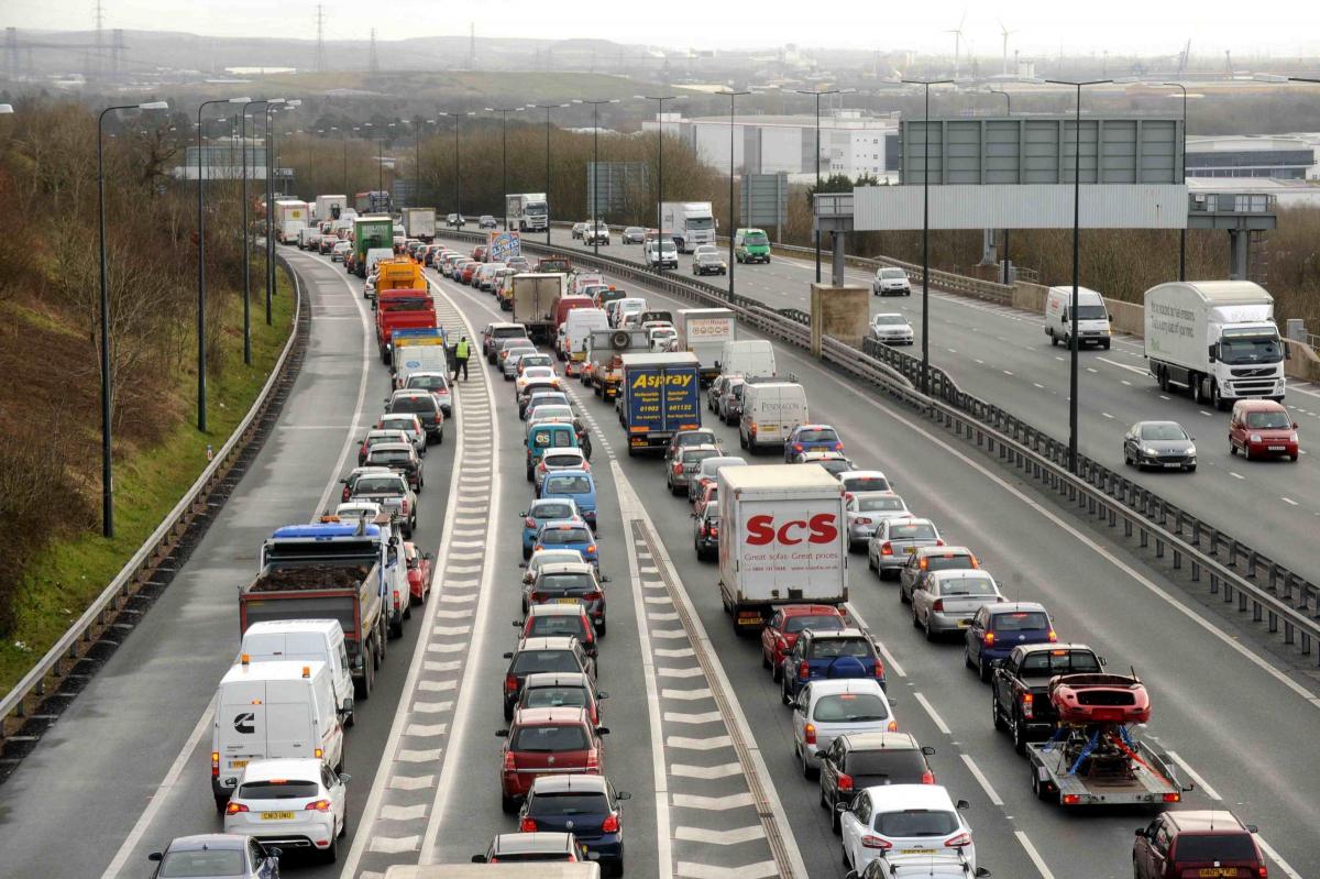
Supporters and detractors cannot deny the simple, central fact however – that and M4 Relief Road, for better or worse, will have a major effect on Newport and the surrounding area.
Anyone keen on finding out more about the project is invited to attend one or more of the following public exhibitions:
l Today, 11am-7.30pm – Castleton Village Hall;
l Thursday and Friday, September 10-11, 11am-7.30pm – Caerleon Town Hall;
l Monday and Tuesday, September 14-15, 11am-7.30pm – Nash Community Centre;
l Wednesday and Thursday September 16-17, 11am-7.30pm – Ebenezer Baptist Church, Magor;
l Monday September 21, 9am-5.30pm – Kingsway Shopping Centre, Newport; and
l Friday and Saturday, September 25-26, 10am-4pm – Lysaght Institute, Corporation Road, Newport.
Among the key features of the proposed M4 Relief Road is a bridge over the River Usk and the neighbouring docks, and four junctions – one at each end of the new road, joining the existing motorway, and two others linking key parts of Newport.
The proposed three-lane section of motorway would be more than 14 miles (23 kilometres) long, running south of Newport between Magor and Castleton.
The junction at Magor would be intended to link with the current M4 into and out of Wales, as well as with the M48 and the B4245, aiming to cut traffic through Magor and improve access to Severn Tunnel Junction railway station.
At the other end, the Castleton junction would connect the new road with the existing M4 into and out of Cardiff.
Intermediate junctions are proposed at Glan Llyn, to connect the east of Newport and the new housing and other developments at the former steelworks site with the road, and at Docks Way, to provide a link with the city centre and the west of Newport.
The new bridge over the River Usk and Newport Docks is undoubtedly the single most ambitious aspect of the whole proposal.
Described as a similar structure to the Second Severn Crossing, it would boast a main span of around a quarter of a mile (440 metres), and would be the second longest bridge structure of its type in Wales and the fourth longest in the UK.
One of the debates over a relief road that is sure to be on-going, is the possible effect it will have on the operation of Newport Docks, an issue about which Associated British Ports has voiced considerable concern.
Impressive as the bridge structure looks in the newly released details on the scheme, whether it is of sufficient height over the docks section to leave present business unaffected, and to allow for future expansion, remains to be seen.
A consequence of the M4 Relief Road, if it goes ahead, is that the existing stretch of the M4 between Castleton and Magor would be reclassified as an ‘A’ road, with changes to be made to traffic management and safety measures.
The Caerleon junction eastbound off the M4 – closed a number of years ago when the A4042 Malpas bypass and the Grove Park roundabout and its slip roads were completed – is earmarked for reopening.
The Welsh Government has published a series of facts and figures about the proposed M4 Relief Road, to coincide with the public exhibitions.
It is stating that an average of 100,000 vehicles a day use the M4 around Newport, though figures vary for each section of the motorway, from 95,500 for junction 24 (Coldra)-junction 25 (Caerleon), to 109,200 for junction 28 (Tredegar Park)-junction 29 (A48M).
Traffic flowing through the Brynglas Tunnels is put at 75,400 vehicles a day.
The Welsh Government also estimates that the relief road would save 10 minutes on a journey between the current junctions 23-29.
The economic disadvantages of problems with the current M4 around Newport, and the benefits of a relief road, are highlighted.
One report last year suggested the cost of delays to road users on the Newport section of the existing motorway to be £78 million. Another suggests that the economic benefit of the new road is likely to be more than double the cost.
There is also a claim that the reduced number of vehicles using the existing M4 as a result of the new road will reduce the amount of pollutants being released, thus improving air quality along the former.
Less than two per cent of the total area of the Gwent Levels Site of Special Scientific Interest will be needed for the new motorway, according to the Welsh Government, which also proposes to plant close to 150 acres of new woodland for the purposes of screening and creating new wildlife habitats.
It is also estimated that around half of the new section of road will cross brownfield land.
While the economic benefits of the project are subject to vigorous debate, the environmental aspects have and will continue to enjoy a high profile.
The leaders of 10 environmental organisations in Wales, including Wildlife Trusts Wales, Friends of the Earth Cymru, RSPB Cymru and Sustrans Cymru, have written to First Minister Carwyn Jones expressing their concern about the relief road proposals
The letter highlights wildlife and climate change concerns, and argues that the project contradicts the Welsh Government’s commitment to sustainable development.


Comments: Our rules
We want our comments to be a lively and valuable part of our community - a place where readers can debate and engage with the most important local issues. The ability to comment on our stories is a privilege, not a right, however, and that privilege may be withdrawn if it is abused or misused.
Please report any comments that break our rules.
Read the rules hereLast Updated:
Report this comment Cancel