

HIGH winds brought by Storm Diana have continued to batter Gwent today, with tomorrow's weather warning upgraded to include the whole of Wales.
The Severn Bridge has been closed to high vehicles due to high winds, as 70mph gusts are set to blast most of the UK throughout today and tomorrow.
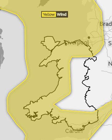
Today's yellow weather warning for wind (Wednesday, November 28) covers most of South, West and North Wales.
Forecasters predict some delays to public transport, and warn journey times could take longer.
But tomorrow's weather warning has been updated to cover the whole of Wales.
The yellow weather warning for wind will be in place between 3am and 2pm tomorrow.
A spell of wet and windy weather is expected, with a small chance of very strong and disruptive winds.
Some short term loss of power and other services is possible, and forecaster have also warned of injuries and danger to life from flying debris.
A Met Office spokesman said: "A very unsettled spell of weather is expected, with strong winds, combined with widespread and in places heavy rain.
"Winds are expected to increase from the far southwest early on Wednesday, spreading northeast, with areas adjacent to the Irish Sea most exposed to the south to southeasterly wind. Wind gusts of 60 mph are expected, with a few more exposed locations seeing 70 mph gusts.
"Winds will also turn west to southwesterly across Northern Ireland and western Scotland later, transferring the main focus for strong winds here, then finally to northern Scotland through the evening. The strong winds will also bring some rough seas and large waves, with some coastal impacts possible.
"Winds will moderate across the south of the warning area by evening and then across remaining parts overnight."


Comments: Our rules
We want our comments to be a lively and valuable part of our community - a place where readers can debate and engage with the most important local issues. The ability to comment on our stories is a privilege, not a right, however, and that privilege may be withdrawn if it is abused or misused.
Please report any comments that break our rules.
Read the rules here