


THESE pictures from the last century show the huge changes Newport has seen – all against the unchanging backdrop of the River Usk. MARTIN WADE investigates the transformation of Newport’s riverfront.
View from the castle

Looking south over the Usk, with the canal to the bottom left. Just out of shot to the left is the castle. PIC: Jan Preece.
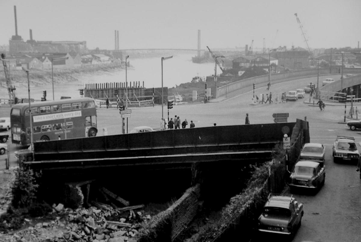
This view taken from the Shaftesbury side of the Old Green shows this bustling area before the current roundabout and interchange was dug out. The picture must have been taken sometime between 1966, when the distant George Street bridge was opened and 1970, when this whole area was broken up and re-modelled. The shot from sometime in the late 60s gives a tantalising glimpse of a remnant of the Monmouthshire canal beneath the road bridge. The canal ran down to where the University of South Wales campus stands now and the Steel Wave.
The canal, looking sad and full of rubble, tells us that it has long been disused. It would be used to form what became the dual-carriageway where traffic now thunders.
Also visible is the power station on the east side of the Usk. This was built in 1902 off Corporation Road and eventually produced electricity for the South West England as well as South Wales. This power station was replaced by one built further down the river at Uskmouth. Newport's famous toastmaster Harry Poloway was chief engineer here for many years.
The cranes belong to the sand wharves which would unload dredgers hauling sand to be used for building from the beds of the Usk and the Severn.
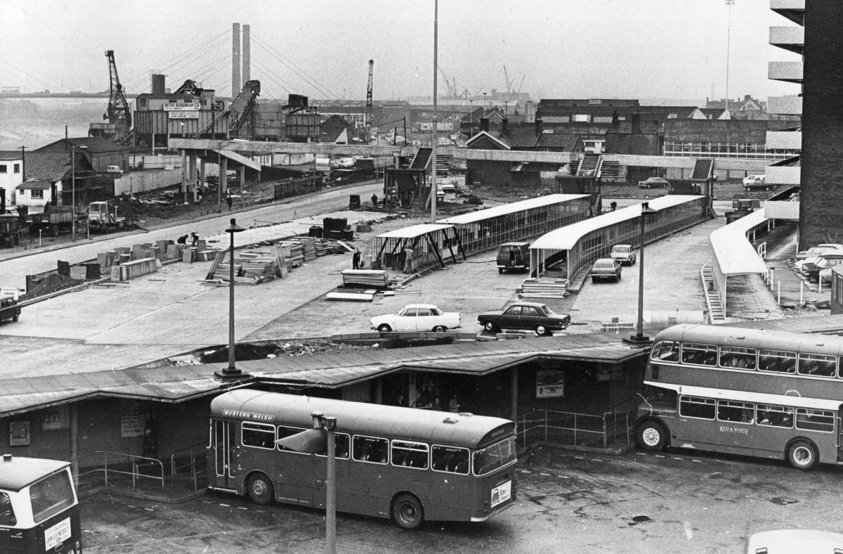
Building the bus station

With Newport bus station being built in the foreground, the riverfront is still being used for industrial purposes
With Newport bus station being built in the foreground, the riverfront is still being used for industrial purposes
This view seems a long way from the lights and shops of Friars Walk. The bus station where Debenhams now stands was still being built in the late 1960s. On the riverside is British Dredging where ships would unload their cargoes of sand and silt scooped from the Severn Estuary. Where the cranes, hoppers and conveyors are in this shot now is the west side of the footbridge and the University of South Wales campus.
The Newport Centre is yet to be built with some terraced housing still visible where it would later be sited. The concrete footbridge is also long gone. While the multi-storey car park from the same era it only departed in 2014 when it was blown up to make way for the new development.
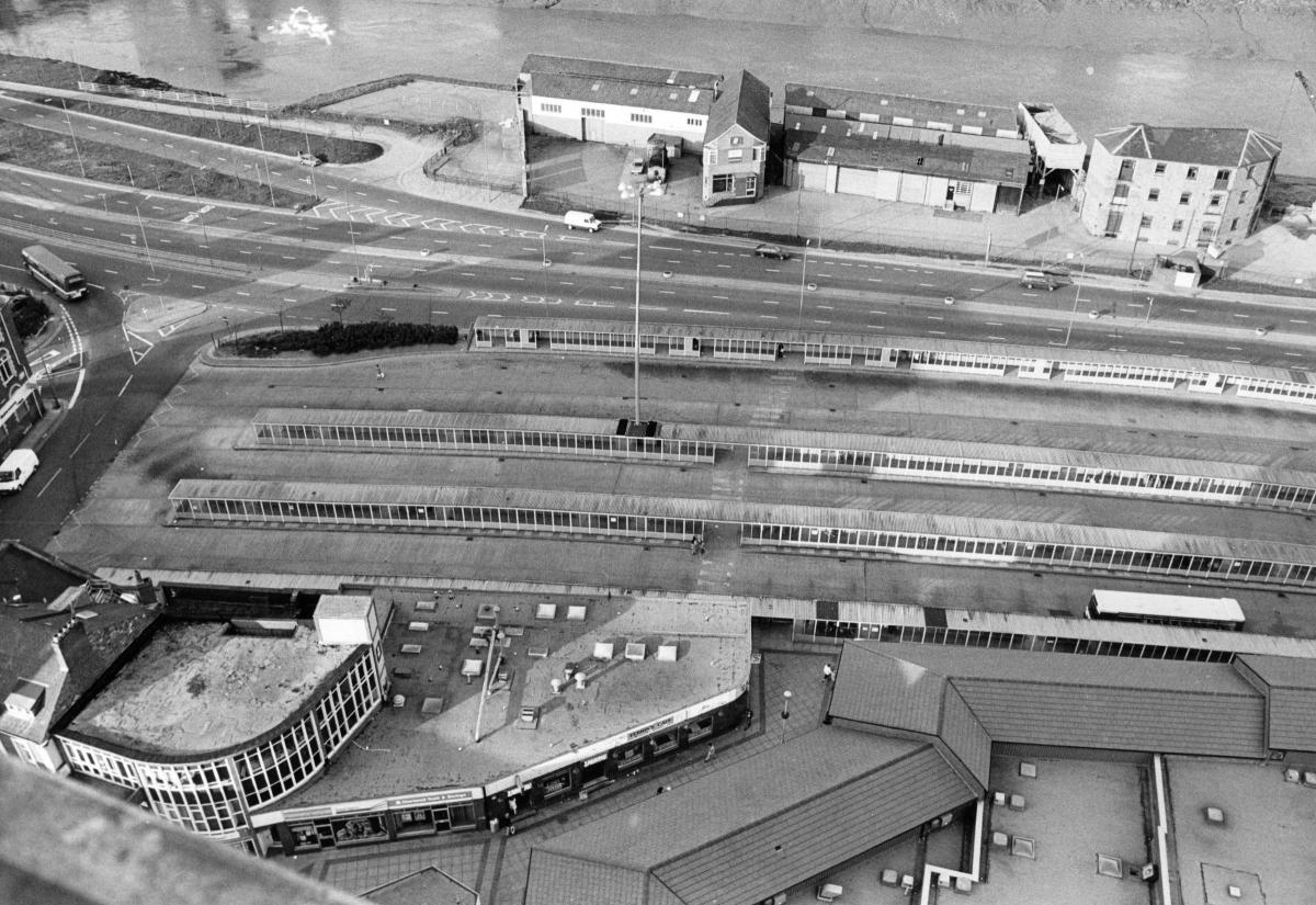
Bus station aerial view

The only surviving building on the riverfront is that on the top-right, now home to the Alacrity Foundation
This shot shows the bus station, now completed, with shops along the bottom-right. The Kingsway is more recognisable then the earlier picture. Across the road, British Dredging look to have gone but some industrial buildings survive. The only parts still standing are the building on the old Moderator Wharf at the top right, now used by Terry Matthews’ entrepreneur project, the Alacrity Foundation and the Potters, the gable end of which can be seen at the bottom left.
The riverfront walk is not complete and the site of the Steel Wave is still occupied by a remnant of the dredging operation.
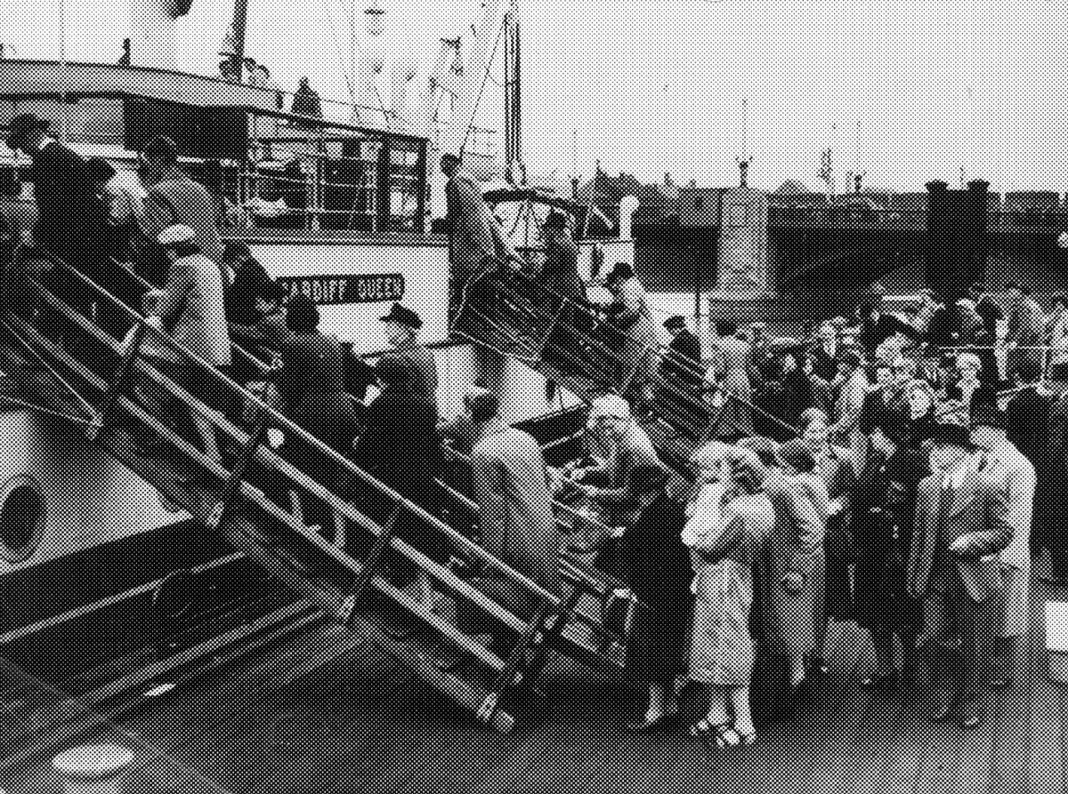
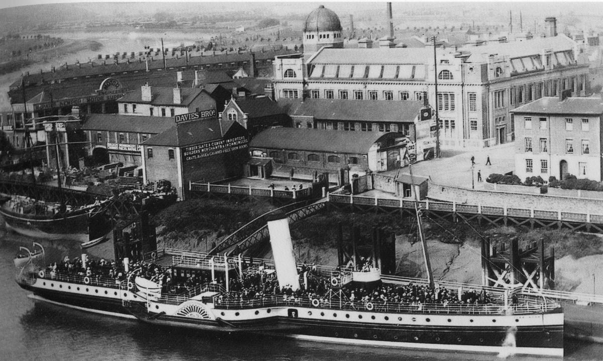
Usk landing stage

Day-trippers join the Cardiff Queen at Davis Wharf in Newport with the town bridge visible in the background
Weathered wooden stumps are all that remain of this place from where ships would sail from the heart of Newport. They are all that is left of where graceful paddle-steamers of P&A Campbell or the White Funnel line would take crowds of day-trippers over the sea.
The passengers, with the town bridge behind them, are boarding the Cardiff Queen, one of several paddlers which would ply their trade between Newport and the West Country ports of Clevedon, Weston and Minehead.
The departing paddle-steamer would face south on Davies Wharf with the Art College to its left and the town bridge behind. The passengers (all wearing hats, naturally) are boarding from the floating landing stage which would rise and fall with the tide.
The paddle steamers were well-adapted to work in the Usk and the Severn with their huge tidal range. Their flat-bottoms meant they could carry on sailing at lower tides when a conventional ship could not.
Old college/landing stage
")
One of the White Funnel steamers gets ready to sail from Davis Wharf. Newport Art College can be seen in the backgound. Pic courtesy of Jan Preece.
The landing stage took its name from Davies Brothers, the builders' merchants sited opposite the Old Art College. Its signage tells how they are importers of 'Timber, slates, cement' and they are 'builders' merchants and ironmongers'. The firm was sited here because this is where their wares would be offloaded from the river. But now this part of the river has been cleansed and is strictly for strolling or living. Those smells of timber and mortar can still be had, just not in the centre of Newport any more.
The open space which sits between the art college and the river was then a labyrinth of industrial buildings, full, no doubt, of carts, calls and smells.
Across the other side of Clarence Place the low-rise resident of the site now occupied by Clarence House can be seen. Here the name of Newport Motor Supplies mark this out as a most modern feature in this shot, especially against the sailing ship and the paddle steamer moored nearby.
West side of river usk

The Glen Usk paddle steamer setting off from Davis Wharf in Newport with the castle and Jay's furniture shop in the background
Here is the west side of the river again, now before British Dredging took over the site on the bank. Visible to the left of the castle is Jays Furniture shop, which was formerly the Shaftsbury Cafe, standing sentinel-like on the bridge. Their large mirror was well-known, with kids stopping to do a Harry Worth impressions in front of it. They would stand in front of the mirror with half of their body reflected and wave their arms up and down, creating the illusion they were jumping up and down.
Cashmores

HMS Verulam and HMS Manxman alongside at Cashmores
This shot is another which shows graphically just how much has changed on the Usk in Newport. Here, the former Royal Navy ships Manxman and Verulam await the cutter's torch at Cashmores the ship-breakers.
Here, ships great and small would meet their end. Some were great battleships like HMS Collingwood, others were liners like the Doric, whose fittings found their way to homes and pubs across Gwent.
They would all meet their end quickly. A ship the size of HMS Manxman would only take a few weeks to break up. A team of workmen with cutting torches would set about the stricken ships.
The structure above the deck would go first and as the cutters did their work and a crane lifted it great chunks of steel and so it went on as they devoured the ship, its hull shrinking towards the Usk mud on which it sat. The men would work around the tide and as the vessel shrank, so the tide would swallow it again, until it all had been cut and removed.
Time was of the essence - the quicker another could be cut up to bring more lucrative scrap.
The site with its cranes, gantries and workshops almost unrecognisable now and is home to student accommodation and a car park, just beyond George Street bridge.
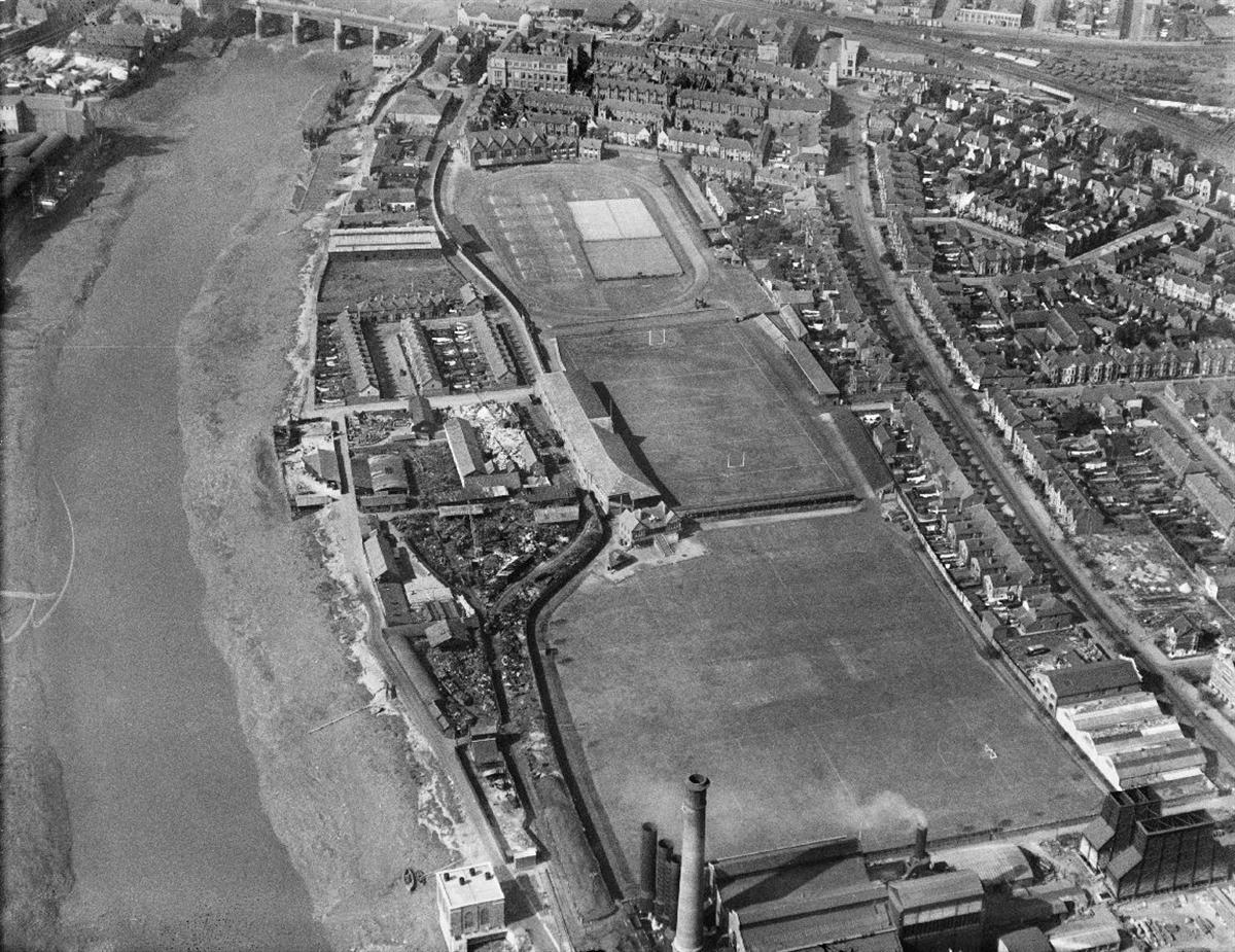
Rodney Parade

This view shows how the east bank has changed
This stunning aerial view from the 1930s shows how much has changed on the east bank of the Usk, but also how much is still recognisable. The power station is clearly visible between the river and Corporation Road and along the edge of Rodney Parade.
The cricket pitch to the north of the power station was sold off 27 years ago. The then just rugby stadium, of course remains, but with the stands rebuilt. Beyond them are the tennis courts, which remain, although tennis is no longer played there.
On the river bank the clutch of terraced houses remain, but now they are surrounded by more houses as flats have been built along the riverside up to the Old Art College. The point where the footbridge now meets the east bank is recognisable as the end of the path between the Rodney Parade stand and the river bank.


Comments: Our rules
We want our comments to be a lively and valuable part of our community - a place where readers can debate and engage with the most important local issues. The ability to comment on our stories is a privilege, not a right, however, and that privilege may be withdrawn if it is abused or misused.
Please report any comments that break our rules.
Read the rules hereLast Updated:
Report this comment Cancel